Constituencies and Settlements - Kunene RC
Click on Cover to Download the Profile

Click on Cover to Download


OPUWO URBAN CONSTITUENCY
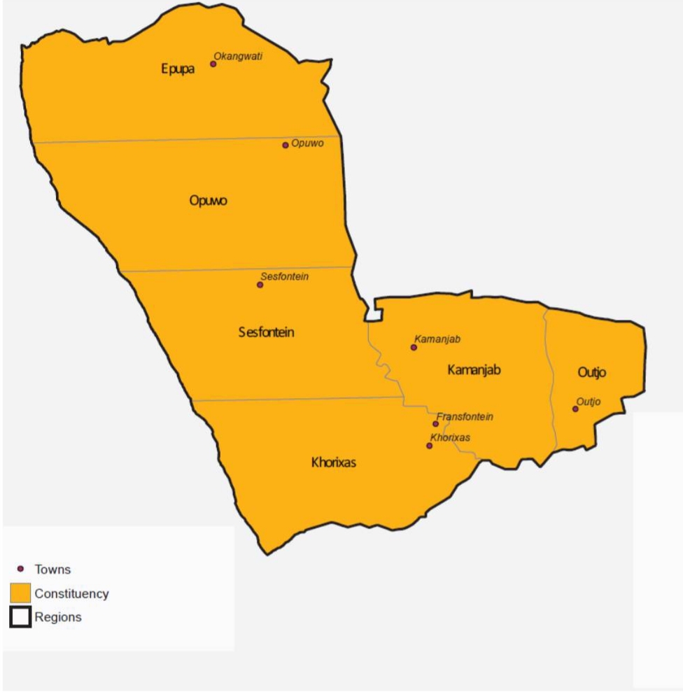
In the North-western part of the region, Opuwo Urban hosts Kunene Regions capital Opuwo town. The constituency with a population of just over 12 000, utilizing 25 758 square kilometres of land is known as Kunene Norths business center. A tourism hub with its beautiful mountains and rock formations, Opuwo is the home of the famous Ovahimba people who have kept to their traditional values and practices despite the general modernization of the rest of the nations cultures & traditions. Opuwo Town is one of the fastest growing towns in Northern Namibia, facilitated by the discovery of iron ore and copper in the mountains around the town and the already existing tourist attractions.
Potential Investment Areas
Becoming the industrial hub of Kunene region due to its strategic location and potential areas of investment lie in land servicing and property development, industrial zoning, accommodation and tourists facilities ( Lodges, Hotels and Bed and Breakfast), housing, shopping malls and service stations at Omakange.
OPUWO RURAL CONSTITUENCY
One of the most remote constituencies in the region established after Opuwo Constituency was divided into two constituencies( Opuwo Urban and Opuwo Rural), this constituency sits on 25, 758 square kilometres of land and has a population of 14 850. Economic activity in this area is centred around communal livestock farming and conservancies.
Potential Investment Areas
It has the potential of becoming the mining hub of the Kunene region through the setting up or establishing a copper processing plant at Otuani. Other potential areas are tourist facilities, butchery and tannery factory,etc.
EPUPA CONSTITUENCY
Far north of the region, Epupa borders Angola and has a population of just over 17 500. Economic activities in the area are mainly focused on agriculture and tourism. Epupa hosts some of the tourism hotspots in the region including Epupa Falls, Otjandjasemo Hot Spring, Swartbooi Graves, Great Trek of Germans and Kapika Traditional Homestead. Okanguati Settlement area is the administration centre of this constituency.
Okanguati Settlement
Okanguati is a proclaimed Settlement in the north of Kunene Region, which is approximately 120km from Opuwo, the regional capital. Okanguati settlement is regarded as the Administration center for Epupa Constituency since the constituency office is situated in Okanguati.
The settlement area has 434 surveyed plots and hosts approximately 554 residents, 434 and 266 of the residents have benefited from the Build Together Program (BTP).
Potential Investment Areas
- Tourism Facilities ( lodges, hostels and camping sites)
- Construction of roads and bridges
- Construction of schools
- Rural electrification
- Construction of a Service Station at Epupa Falls
- Construction of houses in the Settlement ( mass Housing Project)
- Construction of a service station in Okanguati
- Industrial park for emerging local investors
SESFONTEIN CONSTITUENCY
Covering an area of 20 198 square kilometres, Sesfontein Constituency has a population of just over 8000. Economic activity in this area is largely focused on eco-tourism and geo-exploration with +/- 10 privately owned lodges, 6 campsites and 5 communal conservancies housing a variety of wildlife including desert elephants, rhinos, lions, giraffes and diverse birds. The Sesfontein settlement area is the gateway to Cape & Angra Fria, places earmarked for the development of the next harbor.
Sesfontein Settlement
Sesfontein Settlement is located within the Sesfontein Constituency originates from six fountains identified within the vicinity of the settlement area. Sesfontein was proclaimed as a settlement area by the Kunene Regional Council on the 14th of July 2005 and covers an area of 116, 301 hectares. The Settlement area is governed and administering by the Kunene Regional Council, with a satellite office responsible for day-to-day management and administration of the settlement. Sesfontein settlement area is the gateway to Cape and Angra Fira, places earmarked for the development of the development of the next harbour and the Kunene Mouth where diamonds are mined.
Potential Investment Areas
- Green Scheme Crop Production
- Increased tourism facilities and infrastructure
- Road infrastructure Development
- Education and health infrastructure
- Telecommunication infrastructure
- Urban Infrastructure Development (e.g sewer, water, electricity, roads,etc.)
- Additional Tourism Facilities
KAMANJAB CONSTITUENCY
Situated in the south-central part of the region, sitting on 17 130 square kilometres, the Kamanjab Constituency has a population of just over 8000, making it the least populated constituency in the region. Economic activity in the area is mainly split between agriculture and tourism. Kamanjab is positioned well to connect the region to other parts of the nation.
Potential Investment Areas
- Tannery
- Tourism Accomodation and other facilities
- Green Schemes (Tsumamis and Kainatseb localities
- Transport infrastructure and services
- Trophy hunting
KHORIXAS CONSTITUENCY
In the Southern part of Kunene Region, Khorixas Constituency sits on 21 328 square kilometres of land with a population of just over 12 500. The name Khorixas was derived from the Khori tree which can only be found in Khorixas. Tourist sites such as the World Heritage Site, the Petrified Forest and the Buried Mountain are all found in this constituency. Potential for growth lies in industrial development and tourism.
Fransfontein Settlement
The early history of Fransfontein dates back to the 1870s but Fransfontein was first settled in permanently from 1880. Fransfontein Settlement area celebrated in 2015. The settlement area has a township boundary covering 244,566 hectares. The 2011 National Housing and Population Census estimated the total population at 533, with 304 females and 249 males.
The Fransfontein Settlement area was proclaimed and declared through the government gazette by the Government of the Republic of Namibia in 2007. Settlement areas need to be developed in order to ease the burden of migration of people from settlement areas to towns in search of jobs and greener pastures.
OUTJO CONSTITUENCY
In the South-Eastern part of the region you will find Outjo Constituency which covers the surface area of 7466 square kilometres and has a population of just over 12 000. Outjo forms the entry point for consumer goods and services distributed through the region. It is arguably Kunene's commercial hub with farming activities, charcoal production, tourism facilities and retailing.
Outjo Constituency is the commercial hub of the Kunene region, characterized by commercial farming activities, charcoal production, torurism, facilities, meat processing and retailing.
Potential Investment Areas
- Land and Real Estate Development
- Abattoirand Meat Processing
- Tannery
- Tourism Facilities and Infrastructure

 © Government of the Republic of Namibia - All Rights Reserved.